Project background
The 2015 Chennai floods caused immeasurable damage to the life and property across the Chennai Metropolitan. In order to manage the frequent extreme floods occurrences in Chennai and neighbouring ULBs, the Government of Tamil Nadu sanctioned the project “Real Time Flood Forecasting and Spatial Decision Support System - Chennai (RTFF & SDSS) funded by World Bank. RTFF & SDSS is implemented under the Project Development Grand Fund (PDGF) managed by Tamil Nadu Urban Infrastructure Financial Services Limited (TNUIFSL) on behalf of (i) Commissionerate for Revenue Administration (CRA), (ii) Greater Chennai Corporation (GCC) and (iii) Commissionerate of Municipal Administration (CMA). SECON Private Limited, Bangalore, India and JBA Consulting, United Kingdom Joint Venture (SECON-JBA JV) are the Consultant for the project Planning, Setting-up and Commissioning of the Real Time Flood Forecasting and Spatial Decision Support System under the supervision of Indian Institute of Technology, Madras (IIT-M) assisted the TNUIFSL in the implementation of the project.
Project Objectives
The objective of the project is to “Plan, setup and operationalize a Real-Time Flood Forecasting
and Spatial Decision Support System (RTFF & SDSS) for Chennai”.
To achieve this, following specific objectives have been defined.
- To set up a web-based Real Time Flood Forecasting System.
- To develop a Lake and Reservoirs Operation Guidance System.
- To develop Spatial Decision Support System for dissemination of Warnings.
- To set up a Hydro Modelling cum Flood Monitoring Control Room at State Emergency Operation Centre, Ezhilagam, Chennai.
- To set up Flood Monitoring Control Rooms at Greater Chennai Corporation, Kancheepuram, Tiruvallur Collectorates.
- To enhance the capacity of the officials by providing on-the-job and focused training.
Project Components
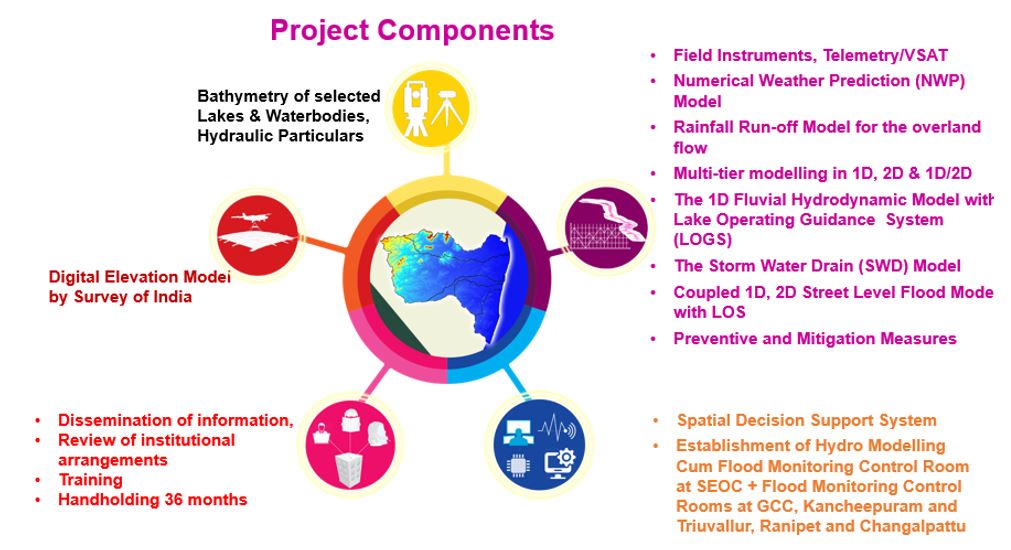
Modelling System
The modelling area has been delineated into 74 watersheds. The total length of modelled river is 989 km.
A total of 5 Numerical Weather Prediction (NWP) models of rainfall forecasts viz., NCEP-GFS, UKMet, IMD-GFS, NCMRWF and ECMWF are used in the model. The street level inundations forecasts are also provided for the major flood vulnerable areas, identified using the historical flood events. Some of the frequently flooded areas are Nungambakkam, Meenambakkam, Velachery, Saidapet, Mambalam and Mudichur.
The Web-DSS is the interface of the flood forecasting system to the end users, developed by SECON-JBA
The hydro-modelling gives reliable forecasts of water level in rivers, lakes, and tanks. It helps the Water Managers by providing timely/advance information on how to operate the lakes and tanks and to minimize the flood damages.
The models involved in the project are:
- Rainfall Forecast Model
- Rainfall-Runoff (Hydrologic) Model
- Channel Flow (1D Hydraulic) Model
- Lake Operation Guidance System (LOGS)
- Storm Water Drain (SWD) Model
- Flood Inundation Model (2D)
- Web-based DSS
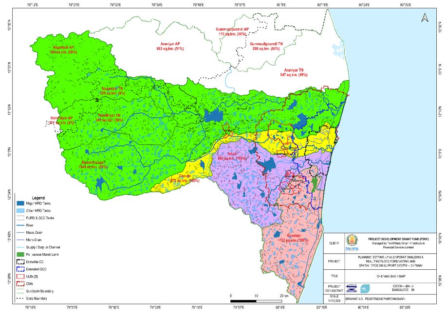
Area of Interest: Chennai Basin
The Chennai basin is located at the northeast corner of Tamil Nadu, between the latitudes 12°40'N and 13°40'N and longitudes 79°10'E and 80°25'E, covering a total area of 4974 km2. The basin falls under Chennai, Kancheepuram, Thiruvallur and Chegalpattu, Ranipet and Vellore districts of Tamil Nadu. River Adyar, Cooum and Kosasthalayar flows through the basin. The Chennai basin comprises of six sub basins viz., Kosasthalayar, Cooum, Adyar, Kovalam, Nandiyar and Nagariyar.
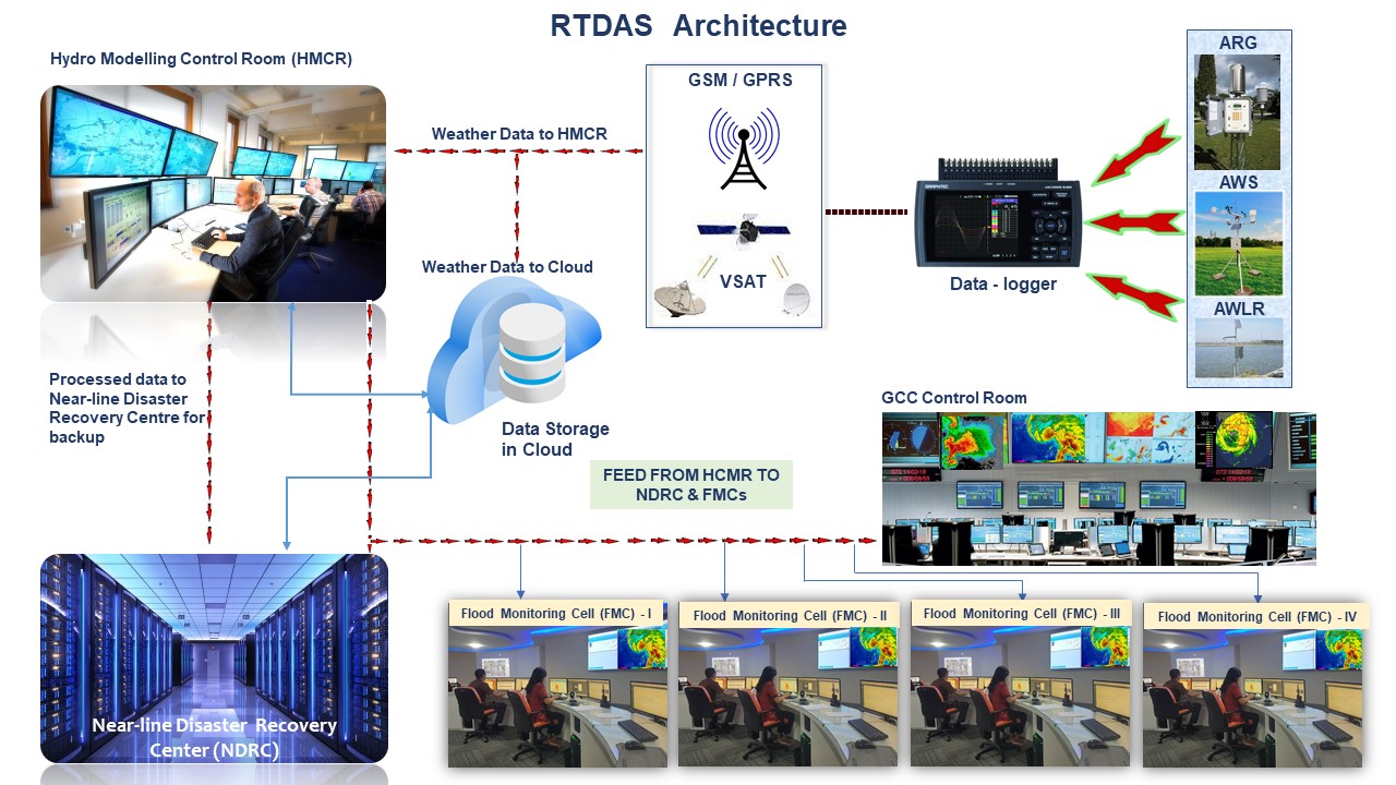
Real-Time Data Acquisition System (RTDAS)
The Realtime Data Acquisition System consists of the following field equipment, which collects the rainfall, weather and water level data and telemetrically transfer to the Control Room at Chennai.
- Network of 117 Automatic Rain Gauges (ARG), to collect rainfall data.
- Network of 30 Automatic Weather Stations (AWS) to measure weather parameters like temperature, Relative Humidity, Wind Speed, Wind Direction, Sun irradiance, Pan evaporation.
- Network of 185 Automatic Water Level Recorders (AWLR) to measure the water level in the lakes, tanks and rivers.
- Network of 58 Gate Sensors (GS) to measure the gate openings in the lakes, tanks and rivers.
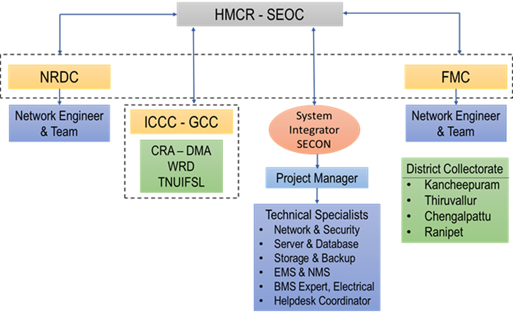
Architecture
Flood Modelling Control Rooms
Flood control rooms are established at strategic locations to receive the data sent by the field equipment, process the data with Hydrological Modelling and issue Flood Alerts over a Web-DSS. The following controls rooms are established under the project.
- Hydro Modelling Control Room (HMCR) at SEOC, Ezhilagam, Chennai.
- Nearline Disaster Recovery Centre (NDRC) & Flood Monitoring Centre (FMC) at WRD HQ.
- Flood Monitoring Centre at District Collectorate, Kancheepuram.
- Flood Monitoring Centre at District Collectorate, Tiruvallur
- Flood Monitoring Centre at District Collectorate, Chengalpattu
- Flood Monitoring Centre at District Collectorate, Ranipet.
-
01 Mission
To provide early flood warnings and assist in dissemination of warnings/ information to strengthen the disaster management capacity of state agencies and stakeholders using real-time data, weather forecast information and mathematical models, thus enhance the community resilience.
-
02 Vision
State Emergency Operation Canter (SEOC) to generate and disseminate Early Flood Warning System to enable the stakeholders to act appropriately and in sufficient time to reduce the possibility of harm or loss
Organogram
To be finalized in consultation with TNUIFSL, IITM and CRA.
Professionals
To be finalized in consultation with TNUIFSL, IITM and CRA.


Operation Control Room
Hydro Modelling Control Room (HMCR) – State Emergency Operation Centre
The Hydro Modelling Control Room (HMCR) is proposed to be established in Commissionerate of Revenue Administration’s Tamil Nadu Disaster Risk Reduction Agency (TNDRRA). The HMCR acts as a central nerve centre for RTFF and SDSS. Receives forecast from NWP models on rainfall, real time data from field equipment like ARG, AWS, AWLR and gate sensors. The HMCR stores the data in Relational Database Management Systems. Operates the hydro models for water level forecasts at river and streets and developing SOPs for Lake Operation Guidance Systems. The flood alerts from the Hydro Modelling Control Room will directly reach the general public without any lag in time. The general public can respond to the emergency flood alerts in time and save themselves. The Integrated Control Command Centre (ICCC) at Ripon Building of GCC, receives feed on flood alerts from HMCR. The HMCR functions as an Integrated Command Control Room from where the Disaster Management Authorities can issue flood alerts and directions to the District Administrators in time to avert flood damages.
Nearline Disaster Recovery Centre (NDRC)
It is proposed to establish the Nearline Disaster Recovery Centre (NDRC) in the existing Flood Control Room in the Office of the Chief Engineer (Operation & Maintenance), WRD, PWD, Chepauk, Chennai - 5. NDRC at WRD acts as one of the nodal centres for RTFF and SDSS. It also facilitates to be a backup centre for hydro modelling servers and store all the data from the HMCR. When the HMCR is down, the data from RTDAS will switch over to database server in the cloud to NDRC.
Flood Monitoring Centre (FMC)
FMCs provides flood alerts on water level in major waterbodies, waterways and streets. Collects feedback from local inputs and upgrades the system. Uploading details of gate openings and water level data of minor tanks manually into the system. The four nodal points of FMC are established in District Collectorate of Kancheepuram, Thiruvallur, Chengalpattu and Ranipet.
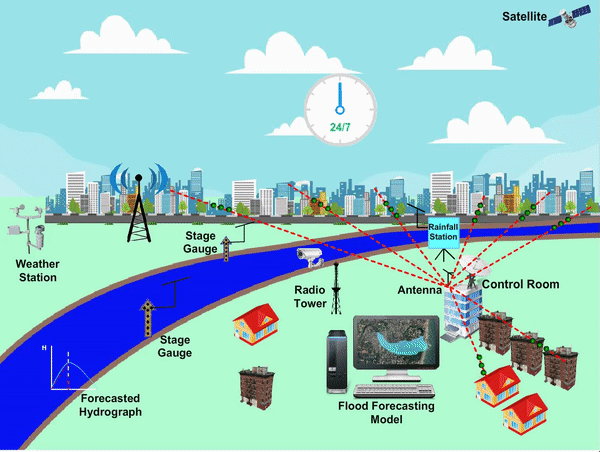
The RTFF & SDSS Operation
- The equipment and servers with the calibrated model are set-up in the HMFMCR.
-
During the rains, the HMFMCR receives the following data in real-time
- The forecast rainfall in the ensuing 3 days, 2 days, 1 day, 12 hrs, 6 hrs from the Numerical Weather Prediction Models (NWP)
- The actual rainfall from the ARG is received at the HMFMCR from the field.
- The weather parameters from the AWS.
- The prevailing water levels / storage in the lakes / tanks are received at the HMFMCR from the AWLRs at field.
- The inflow into the lakes / tanks from the AWLRs in the supply channels.
- The gate opening positions of the lakes / tanks are received from the Gate Sensors of the lakes / tanks.
- The Modelling Servers simulate the rainfall-runoff in the terrain, Storm Water Drains (SWD) and Rivers.
- The consequent flood inundation extent and depth over the streets, wards, zones of the GCC and ULBs are simulated.
- The WRD officials give optimised manner of Lake Operation as an input scenario and run the models.
- The net potential Flood Inundation and Hazards are disseminated to the flood managers and the general public over Web, TV, email and mobile platforms.
- The Revenue authorities take flood mitigation measures like evacuating the people in advance from potential flood inundation areas, as disseminated from the system.
- People can give useful feedback to HMFMCR for fine-tuning the system, like actual depth of floods in their localities.
- The flood damages are minimised, using the RTFF & SDSS.
RTDAS Space Sponsors
YMCA College of Physical Education
Nandanam, Chennai – 600 035.

KCG College of Technology
KCG Nagar, Rajiv Gandhi Salai,Karapakkam, Chennai – 600 097.

Jerusalem College of Engineering
Velachery main road, Narayanapuram, Pallikaranai, Chennai – 600 100
Jeppiaar Engineering College
Jeppiaar Nagar, Rajiv Gandhi Salai, Chennai - 600 119.

Mohammad Sathak College Campus
Sholinganallur Main Rd, Medavakkam, Chennai, Tamil Nadu 600100.

Boomi Bricks
Perathur, Tiruvallur – 602 021.
GH India Auto Parts
No.12, Othappai Taluk, Uthukkottai,Tiruvallur – 602 023.
Suncity Apartments
VGP Sun City, Agaram, Tiruvallur – 631 203.

Saveetha School of Management
Numbal, Thiruverkadu, Chennai – 600 056.

Vel Tech Rangarajan Dr. Sagunthala R&D Institute of Science and Technology
No.42, Avadi-Vel Tech Road, Poonamallee - Avadi High Rd, Vel Nagar, Chennai - 600 062 .

Caterpillar India Pvt Ltd
Melnallathur Post, Tiruvallur – 602 004
Adani Kattupalli Port Private Limited
Kattupalli Road, Kattupalli, Tiruvallur – 600 120
Siddharth Industries
Goonipalayam, Tiruvallur - 602 026.

GRD College of Education
Pudur Village, Tiruvallur - 631210
Sevalaya Campus
Kasuva Village, Pakkam PO, Near Thiruninravur, Tiruvallur – 602 024.

Jaya Agricultural College (JAC)
Arakkonam to Thiruvalangadu High Road, Vyasapuramn Tiruvallur - 631 210
Vedamaharishi Polytechnic College
Athimanjeripet, Tiruvallur – 631 202
Pipe line Bridge near L&T transit house
Ennore Kattupalli, Tiruvallur – 600 120
Sabi Foods Project by Laksh Infras
Sabi Foods Project by Laksh Infras, Pallur,Kancheepuram – 631 502
International Institute of Biotechnology & Toxicology
Shanmuga Nagar, Padappai, Kancheepuram – 601 301.
Little Flower Hr. Sec. School
Theresapuram, Kancheepuram – 602 105.

Saveetha Institute of Medical and Technical Sciences
Saveetha Nagar, Sriperumbadur Taluk, Kanchipuram – 602 105.
Sri Venkateshwara Engineering College
Post Bag No.1, Pennalur Village, Sriperumbudur, Kancheepuram – 602 117 .

Ocean Healthcare Private Limited
SH58, Orathur,Chengalpattu - 603003.

Hindustan Institute of Technology & Science
Rajiv Gandhi Salai (OMR), Padur, Kelambakkam, Chengalpattu - 603 103

Vellore Institute of Technology - VIT Chennai
Kelambakkam - Vandalur Rd, Rajan Nagar,Chengalpattu – 600 127

B. S. Abdur Rahman Crescent Institute of Science and Technology
GST Road, Vandalur, Chengalpattu - 600 048.

Saraswathi Velu College of Engineering
Jambukulam Road, Melvenkatapuram, Sholinghur, Ranipet - 631 102
Sri Vidhya Mandir Matric. School
Gandhi Nagar, Padmapuram, Sholinghur, Ranipet – 631 102

Vedavalli Vidyalaya,
Anaicut St, Walajapet, Tamil Nadu 632513.

Indian Institute of Technology Madras
IIT P.O., Chennai - 600 036.
Chennai Metropolitan Water Supply and Sewerage Board
No. 1, Pumping Station Rd, Chintadripet, Chennai, Tamil Nadu 600031
Forest Department
No. 1, Panagal Building, Jenis Rd, Saidapet, Chennai, Tamil Nadu 600015.

National Highways Authority of Indiag
No. D P 34, Sri Towers South Phase, 3rd Floor, Guindy, Chennai, Tamil Nadu 600032.
Southern Railways
NGO Annexe, George Town, Chennai, Tamil Nadu 600003.
Department of School Education
Secretary to Government, School Education Department, Government of Tamil Nadu, Fort St. George, Chennai-9. .
Revenue and Disaster Management Department
Kamarajar Promenade, PWD Estate, Chepauk, Triplicane, Chennai, Tamil Nadu 600005.
State Highways Department
HRS Campus, 76 Sardar Patel Road, Guindy, Chennai - 600 025.
Water Resources Department
P.W.D.,CHEPAUK, CHENNAI-600005.
Directorate of Medical and Rural Health Services
359, Anna Salai, Chokkalingam Nagar, Teynampet, Chennai, Tamil Nadu 600006
Directorate of Rural Development & Panchayat Raj Department
Panagal Maligai, 4th & 5th floor, Abdul Razzak St, Saidapet, Chennai, Tamil Nadu 600015.

Tamil Nadu Agricultural University
10th St, Block U, Anna Nagar, Chennai, Tamil Nadu 600040.

Tamil Nadu Veterinary Animal Sciences Universitys
Madhavaram Milk Colony Rd, Madhavaram Milk Colony, Chennai, Tamil Nadu 600051.

Tamil Nadu Electricity Board Limited
No 825, Link Rd, Anna Salai, Triplicane, Chennai, Tamil Nadu 600002

CSIR-Structural Engineering Research Centre
CSIR Road, CSIR Campus, Chennai, Tamil Nadu 600113.

Tamil Nadu State Biodiversity Board
TBGP Campus, II Floor Velacherry-Tambaram Main Road, Post, Nanmangalam, Medavakkam, Chennai, Tamil Nadu 600100
National Disaster Response Force
Indira Nagar, Adyar, Chennai, Tamil Nadu 600020
State Industries Promotion Corporation of Tamil Nadu Ltd (SIPCOT)
No 19 A, Rukmani Lakshmipathi Rd, Egmore, Chennai, Tamil Nadu 600008
Important Links
- IMD - https://mausam.imd.gov.in/
- WRD TN - http://www.wrd.tn.gov.in/
- Groundwater department - http://www.groundwatertnpwd.org.in/
- CRA DMA - https://www.tn.gov.in/detail_contact/7443/4/
- Kancheepuram district - https://kancheepuram.nic.in/
- Thiruvallur district - https://tiruvallur.nic.in/
- Chegalpattur district - https://chengalpattu.nic.in/
- Ranipet district - https://ranipet.nic.in/
- National remote sensing centre - https://www.nrsc.gov.in/
- India WRIS - http://www.india-wris.nrsc.gov.in/
- Central Water Commission - http://www.cwc.gov.in